|
||
|

|
卫宏健 , 李志刚, 迟娇娇, 车生泉
上海交通大学 农业与生物学院, 农业部都市农业(南方)重点实验室, 上海200240
WEI Hong-jian, LI Zhi-gang, CHI Jiao-jiao, CHE Sheng-quan
文献标识码: 1671-9964(2016)01-0091-08
文章编号: 1671-9964(2016)01-0091-08
收稿日期: 2014-11-14
网络出版日期: 2016-01-20
版权声明: 2016 上海交通大学期刊中心 版权所有
基金资助:
作者简介:
作者简介: 卫宏健(1989-), 男, 硕士生, 研究方向:生态规划与城市休闲, E-mail:weihj724@126.com;
通讯作者: 车生泉(1968-), 男, 博士, 教授, 博士生导师, 研究方向:景观生态规设计, E-mail:chsq@sjtu.edu.cn
展开
摘要
公共开放空间是市民公共活动的重要载体, 高品质公共开放空间的建设对构建现代化宜居城市具有重要作用。为分析上海建成区公共开放空间现状、优化空间使用, 文章选取8处代表样点, 进行了公共开放空间类型与分布调研, 总结出无核型、单核型、双核型、多核型、轴向型及两极型6种典型模式; 同时, 从空间数量和使用两方面对不同模式进行了对比, 分析了现状问题; 最后针对性提出空间优化对策, 以期能够对上海公共开放空间的规划与建设有所助益。
关键词:
Abstract
Public open space is the most popular place used in people’s public life, and the construction of high-quality public open space plays an important role in the modernization construction of livable city.This article focuses on the situation analysis and optimization of public open space in Shanghai city.Eight representative sampling sites were selected and investigated, then, six typical structure models of Shanghai public open space, including no-core type, single-core type, dual-core type, multi-core type, the axial type and the bipolar type, were constructed.By comparing the quantity and use of public open space in different models, some optimization countermeasures were put forward, in order to guide the planning and construction of the following.
Keywords:
随着上海社会经济的快速发展, 城市居民对休闲游憩空间的要求也逐渐提高[1]。作为市民休闲活动的主要空间载体, 建成区公共开放空间“为城市带来了活力与色彩, 为城市生活提供了多样化的可能性”[2]; 其在改善城市环境、促进市民交流等方面具有举足轻重的作用, 在国内外众多城市规划概念中, 亦一直扮演着重要角色[3, 4]。
国际上对公共开放空间的研究开始较早, 不同学者从公共开放空间功能与价值探讨[5-7], 公共开放空间对城市空间布局影响[8, 9], 公共开放空间评价、保护及其规划[10-12]以及公共开放空间景观格局演变及其机制分析[13, 14]等方面展开了相关研究。我国对公共开放空间的相关研究与探索始于20世纪80年代, 相关学者从城市公共开放空间发展与历史演变[15, 16]、空间规划设计方法[17]、公共开放空间品质、价值评价[18, 19]等角度对公共开放空间进行了研究。
目前国内研究尚未产生公共开放空间清晰完整的定义[17, 20]; 相关理论研究亦多着眼于宏观层面[21-24]; 对公共开放空间深入的调查与探究则多从公园[25]、广场[26]、街道[27]、绿道[28]、郊野公园[29]、农业观光园[30]等某一类型公共开放空间入手, 从整体视角对具体城市公共开放空间体系及其现状调查的研究十分缺乏。上海作为中国最发达的城市之一, 正处在优化发展的新时期。基于现状, 构建上海建城区公共开放空间典型模式, 梳理城市公共开放空间现状并探索其优化提升策略, 对提升上海城市形象和宜居水平, 构建国际化大都市具有重要意义。
参考相关研究, 本文定义“建成区公共开放空
间”为:位于城市建成区范围内, 存在于建筑实体外部, 对所有城市居民开放, 可供居民方便使用的开敞空间实体。它是承载城市居民公共活动的重要场所, 既包括建成区内的公园绿地、广场等点、面状空间, 也包括街道等线型休闲空间。
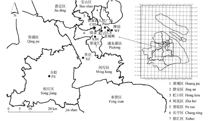
综合考虑区位、形成时期和空间类型特点, 研究共选择人民广场(PSS)、瑞金(RJ)、徐家汇(XJH)、曹家渡(CJD)、莘庄(XZ)、方松(FS)、老城厢(LCX)及潍坊(WF)8处调研样点(表1, 图1)。
表1 研究样点选择
Tab.1 Characteristics of the sample areas
| 样点 Samples | 面积/km2 Scale | 区位 Location | 主要形成时期 Formation period | 类型特色 Feature |
|---|---|---|---|---|
| 人民广场 | 1.41 | 城市中心 | 建国前-20世纪90年代 | 城市中心 |
| 瑞金 | 1.72 | 中心城区 | 19世纪中叶-20世纪初 | 历史租界区 |
| 徐家汇 | 1.42 | 城市副中心 | 20世纪80-90年代 | 商业中心 |
| 曹家渡 | 1.53 | 中心城区 | 20世纪80-90年代末 | 主城住宅 |
| 莘庄 | 1.76 | 近郊城区 | 20世纪90年代 末-21世纪初 | 新城住宅 |
| 方松社区 | 2.36 | 远郊新城 | 21世纪初 | 卫星城住宅 |
| 老城厢 | 1.66 | 中心城区 | 元代-建国前 | 历史风貌区 |
| 潍坊 | 2.09 | 中心城区 | 20世纪60-80年代 | 工人新村 |
图1 研究样地选取注:以英文翻译首字母作为样点名称缩写
Fig.1 Locations of the survey samplesNote:Use acronyms as the short name of samples
1.3.1 公共开放空间类型与分布调查
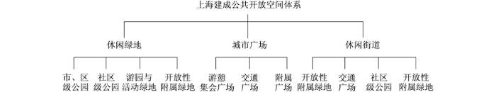
对样点进行现场踏勘, 观察并记录样点范围内可供居民开展休闲活动的公共开放空间。依据上海建成区公共开放空间分类体系(图2)及其界定标准, 将观察到的场地进行类型界定, 并标记其位置、尺寸及形状。
图2 上海建成区公共开放空间分类体系
Fig.2 Classification of public open space in Shanghai city proper
1.3.2 公共开放空间居民休闲活动观察
选取样点内具有代表性的休闲绿地、城市广场和休闲街道各2~4处作为观察点。根据市民休闲活动规律, 将一天分为早晨(7:00-9:00)、上午(10:00-12:00)、中午(13:00-15:00)、下午(16:00-18:00)及夜间(19:00-21:00)5个时段, 分工作日和节假日, 对样点空间使用进行连续观察并记录相关数据。
1.3.3 公共开放空间对比分析
(1) 空间数量:休闲绿地和城市广场统计总面积, 计算面积比, 进行比较分析; 考虑到不同样点内城市道路密度的差异, 可能影响到休闲街道的数量, 研究定义“休闲街道相对密度”作为对比线性空间数量的指标, 有:
休闲街道相对密度
(2) 空间使用:基于工作日、节假日各观察点数据处理, 计算“公共开放空间使用强度”对比分析不同样点空间现状使用, 有:
空间使用强度
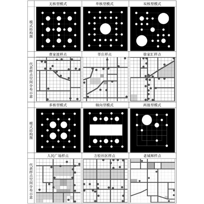
以样点核心节点数目及不同类型空间组合方式为依据, 总结出上海建成区公共开放空间无核型、单核型、双核型、多核型、轴向型和两极型6种典型模式(图3)。其中:无核型模式指样点内无大规模和较强吸引力的核心节点的模式, 以曹家渡样点为代表。单核型模式指仅有1处规模较大、吸引力强的核心节点的模式, 以莘庄样点为代表。双核型模式指样点具有2处核心节点的模式, 以徐家汇样点为代表。多核型模式指具有3处及以上核心节点的模式, 以人民广场样点为代表。轴向型模式指多处大型公共开放空间连续分布, 形成区域公共开放空间带状主轴的结构模式, 以方松样点为代表。两极型模式指公共开放空间的分布集中偏向样点某一方位, 主要的公园绿地、城市广场和休闲街道在该侧具有相对完整的结构, 而另一侧公共开放空间相对缺乏的模式, 以老城厢样点为代表。
2.2.1 空间数量
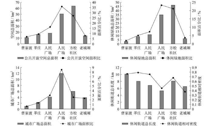
(1) 空间总量:就空间绝对数量而言, 方松样点(63.74 hm2)>人民广场样点(50.45 hm2)>徐家汇样点(18.02 hm2)>莘庄样点(16.28 hm2)>老城厢样点(13.66 hm2)>曹家渡样点(10.56 hm2)。以公共开放空间面积比为指标, 人民广场样点(35.85%)>方松样点(27.02%)>徐家汇样点(12.72%)>莘庄样点(9.26%)>老城厢样点(8.20%)>曹家渡样点(6.89%)。
计算各样点公共开放空间人均面积(表2), 发现方松样点和人民广场样点远超其他样点; 莘庄与徐家汇样点相仿, 数量居中; 而老城厢和曹家渡样点由于大规模公园、广场空间的缺失, 人均公共开放空间面积未超过2 m2。
参考《城市用地分类与规划建设用地标准》, “规 划人均绿地面积不应小于10.0 m2/人, 其中人均公园绿地面积不应小于8.0 m2/人”, 同时绿地和广场用地应占规划建设用地的10%~15%。由此, 从空 间总量来说, 方松和人民广场样点公共开放空间总量足够; 莘庄和徐家汇样点存在一定的不足; 而老城厢、曹家渡样点空间总量则严重不足。
图3 不同模式及代表样点现状示意图注:绿色块——核心绿地; 橙色块——核心广场; 红色点——其他小型节点
Fig.3 Schematic diagram of different structure models and representative sample areasNote: green block-large green space, orange block-large square, red dot-other space node
表2 不同模式样点人均公共开放空间面积
Tab.2 Per capita area of public open space in different models
| 类别 Type | 曹家渡 CJD | 莘庄 XZ | 徐家汇 XJH | 人民广场 PSS | 方松 FS | 老城厢 LCX |
|---|---|---|---|---|---|---|
| 公共开放空间总面积/hm2 | 10.56 | 16.28 | 18.02 | 50.45 | 63.74 | 13.66 |
| 样点区域人口/万人 | 7.5 | 2.5 | 3.5 | 2.5 | 2 | 7 |
| 人均公共开放空间/(m2/人) | 1.41 | 6.51 | 5.15 | 20.18 | 31.87 | 1.95 |
(2) 不同类别空间数量:休闲绿地方面, 就总面积而言, 方松样点(46.50 hm2)>人民广场样点(34.88 hm2)>徐家汇样点(10.89 hm2)>莘庄样点(8.65 hm2)>老城厢样点(6.34 hm2)>曹家渡样点(2.94 hm2)。
比较绿地面积比, 人民广场样点(23.25%)和方松样点(21.14%)休闲绿地面积占比最高; 徐家汇(7.26%)样点内绿地形成双核心, 占比次之; 莘庄(5.09%)和老城厢(3.82%)样点内仅有1处核心休闲绿地, 比例相对较低; 无核型模式本身缺少大型绿地, 因此曹家渡(3.82%)休闲绿地数量最少。
城市广场方面, 就总面积而言, 人民广场样点(12.03 hm2)>方松样点(5.97 hm2)>徐家汇样点(4.13 hm2)>老城厢(3.86 hm2)>莘庄样点(2.28 hm2)>曹家渡样点(0.88 hm2)。
比较广场面积比, 人民广场样点占比最大, 达到8.55%, 这与其城市中心区位以及休闲、商业广场林立有直接关系; 徐家汇样点(2.91%)、方松样点(2.53%)、老城厢样点(2.32%)广场面积比较为接近; 单核型的莘庄样点(1.30%)和无核型的曹家渡样点(0.57%)广场空间存在明显不足。
休闲街道方面, 就总长度而言, 曹家渡样点(10.13 km)>方松样点(8.14 km)>莘庄样点(8.10 km)>徐家汇样点(6.87 km)>老城厢样点(6.58 km)>人民广场样点(5.35 km)。计算休闲街道相对密度后发现:莘庄(0.79)、曹家渡(0.77)、徐家汇(0.75)、方松社区(0.68)4处样点休闲街道密度相对接近, 明显高于人民广场(0.45)和老城厢(0.38)。分析原因, 前四者表现出休闲街道沿城市干道分布的特征, 相对密度近似; 而人民广场和老城厢因为城市中心用地的限制, 休闲街道不成体系, 故相对密度较低。
2.2.2 空间使用
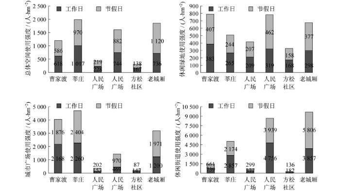
(1) 总体使用强度:总体空间使用强度:莘庄(1 987人/hm2)>老城厢(1 856人/hm2)>人民广场(1 626人/hm2)>曹家渡(1 204人/hm2)>徐家汇(447人/hm2)>方松(305人/hm2)。莘庄样点由于大型户外公共活动的开展, 以及近交通枢纽, 公共开放空间总体使用强度最高; 老城厢和曹家渡样点的高使用强度则与区域内的高人口密度相关; 人民广场地处城市中心, 较多的游客量大大提升了空间使用强度; 而由于室内商业空间的分流, 徐家汇样点使用强度较低; 方松社区则因为远郊卫星城的区位, 居住人口和外来休闲人数都较少, 使用强度最低。
(2) 不同类型空间使用强度:休闲绿地使用强度:曹家渡(790人/hm2)>人民广场(781人/hm2)>老城厢(675人/hm2)>莘庄(509人/hm2)>徐家汇(416人/hm2)>方松社区(326人/hm2)。
广场使用强度:莘庄(4 664人/hm2)>曹家渡(4 044人/hm2)>老城厢(3 171人/hm2)>人民广场(1 439人/hm2)>徐家汇(355人/hm2)>方松社区(234人/hm2)。
曹家渡样点内缺乏绿地、广场等, 因此导致少数此类空间的高使用强度; 莘庄样点由于太极、广场舞等群体活动的广泛开展, 绿地、广场表现出较高的使用强度; 人民广场和老城厢由于接待游客量大, 绿地、广场亦保持着较高的使用强度; 徐家汇和方松样点的低强度则与总体空间使用强度一致, 徐家汇受区域内室内商业的影响, 方松则受限于偏远的城市区位。
休闲街道使用强度:老城厢(9 663人/hm2)>人民广场(8 695人/hm2)>莘庄(5 031人/hm2)>曹家渡(1 400人/hm2)>徐家汇(676人/hm2)>方松社区(318人/hm2)。样点居住人口越多, 越临近城市中心或区域中心, 一般休闲街道使用强度越高。
综合样点空间调查与空间对比分析, 发现不同模式样点现状主要存在空间数量、使用及管理3方面问题, 其中:无核型-曹家渡样点空间总量不足、公园绿地和广场类型缺失、空间使用强度过高以及部分区域环境质量较差; 单核型-莘庄样点空间总量欠缺、核心节点部分时段高强度使用, 部分商业街区环境较差; 双核型-徐家汇样点表现出了空间总量缺失和空间使用强度低下2方面问题; 多核型-人民广场样点在休闲街道类型上存在缺失, 街道总量亦存在不足, 同时街道和绿地的使用强度过高, 但广场使用强度低下; 轴向型-方松样点公共开放空间总量充足, 但存在文化型街道空间类型缺失, 同时空间使用强度低下, 养护管理也存在问题; 两极型-老城厢样点亦存在空间总量的不足, 且社区级公园、开放性附属绿地、游憩集会广场等空间类型缺失, 同时, 空间结构较为完善的北侧使用强度过高, 南侧则存在严重的空间维护问题。
针对现状问题, 研究从“空间增量”、“空间活化”和“空间净化”三个方面针对性提出优化对策。
针对不同模式样点现状, 从空间数量补充和空间类型补充2方面进行空间增量。
曹家渡样点和老城厢样点现状空间总量严重不足, 又受限于城市用地, 空间增量时应以改造现有小规模城市边角空间为主, 建设适用的袖珍游园和广场; 同时, 开放现状条件较好的附用、附属绿地增加, 样点空间总量。
曹家渡样点建设商业型为主的休闲街道体系, 老城厢样点则应结合自身历史文化风貌, 建设文化、商业复合的休闲街道网络。
徐家汇和莘庄样点主要问题在于空间总量存在一定的不足。根据样点用地情况, 在徐家汇样点, 规划主要采取附属绿地开放、小型节点新建等方式增加空间总量, 并重点建设休闲街道网络加强公共开放空间联系; 莘庄样点, 规划采取防护绿地休闲化改造、暂未利用地块临时使用; 人民广场和方松样点空间总量充足, 但人民广场样点休闲街道空间较少, 应加强休闲街道建设; 方松样点作为城市新区, 现状空间数量方面问题不大, 保持现状即可。
针对空间使用问题, 分析不同模式样点空间使用重点处理问题, 提出相应的优化对策。
(1) 曹家渡、老城厢样点:受限于城市建设用地的短缺, 对曹家渡和老城厢样点的空间优化应以休闲街道的优化提升为主。
曹家渡样点现状有较为完善的休闲街道, 对其优化提升, 应从“加强休闲街道衔接”和“特色休闲街道建设”两方面着手。加强休闲街道衔接方面, 修复休闲街道断开路段, 加强街道联系; 特色休闲街道建设指构建区域“三横四纵”的休闲街道网络, 三横包括余姚路、武定路和昌平路两侧休闲街道; 四纵包括胶州路、延平路、武宁路和万航渡路两侧街道。
老城厢样点位于城市历史文化风貌保护区, 对其休闲街道规划应在确定保护对象和道路分级的基础上, 重点打造复兴东路、安仁街和乔家路三条商业、文化休闲型街道。
(2) 人民广场、徐家汇样点:人民广场和徐家汇样点位于城市中心和副中心, 均有较优质的公园绿地建设。
人民广场样点内部大型绿地和广场南北绵延成带, 其规划重点在于打造区域休闲街道体系。规划重点在于延伸现有休闲街道, 加强街道连接; 重点打造东西向延安东路和南北向云南中路、黄陂南路周边休闲街道。
徐家汇样点2处主要休闲绿地分布于样点东北和西南角, 其中东北角徐家汇公园使用强度较低, 规划应从休闲街道网络的完善入手, 构建内外联系的区域休闲街道网络, 重点建设天平路(衡山路-肇嘉浜路)、肇嘉浜路和南丹路, 联系区域居住区和公园; 同时规划建设辛耕路商业步行街区, 形成东西连接天钥桥路和宛平南路的休闲走廊。
(3) 莘庄、方松样点:莘庄和方松样点均具备一定的公共开放空间总量和较为丰富的空间类型, 对空间的活化主要考虑现有空间的提升。
莘庄样点存在使用强度过高的现象, 对此首先应调整公共开放空间布局, 选择合适的区域增建公共开放空间, 进行分流; 同时优化空间设计, 增加开敞场地, 分散座椅等服务设施以应对过多的使用人群。
方松样点具有最大的公共开放空间总量, 规划应从空间优化角度着手, 优化提升区域公共开放空间环境, 重点改造现状质量较差的部分。
针对因养护管理不到位导致的空间脏乱差等问题, 应在进行空间活化的基础上, 加强空间维护。
曹家渡样点, 现状主要存在缺乏服务设施, 街道空间环境质量差, 乱停车等问题。后期应在补充相关服务设施的基础上加大环境卫生的整治和维护力度, 同时加强区域停车管理。
莘庄样点, 现状部分街区环境较差、乱停车现象严重; 公园关门过早亦影响居民的使用。后期应采取环境卫生综合治理手段, 重新安排停车位并加强停车管理, 同时建议延长公园开放时间2 h。
徐家汇样点和人民广场样点则存在夜间照明不够的问题, 应加强相关设备的检修, 补充照明设施。
方松样点存在设施维护不到位、部分空间节点环境质量差的问题, 后期应定期检修、更新服务设施设备, 并整治部分区域环境卫生。
老城厢的空间管理问题主要存在于区域南部, 现状缺乏服务设施、存在停车问题。后期在整治环境卫生的同时, 还应补充必要的服务设施, 加强停车管理。
不同于以往以案例分析和经验借鉴为主的研究方式, 本文结合上海实际情况, 选择8处样点进行了公共开放空间调研, 归纳了上海建成区公共开放空间6种典型模式, 对比分析了现状存在的主要问题, 并提出了对应的优化对策与建议。
然而, 鉴于上海城市建成区规模巨大、类型多样。虽有所考虑, 但选取的8处样点可能难以全面反映出所有上海建成区类型特征; 同时, 针对不同样点公共开放空间休闲需求差异性的对比研究本文尚未涉及, 相关内容的深化将是未来的研究重点。
The authors have declared that no competing interests exist.
| [1] |
|
| [2] |
城市公共开放空间设计探讨 [J].DOI:10.3969/j.issn.1006-0022.2004.05.010 URL [本文引用: 1] 摘要
城市公共开放空间的设置类型和数量应视每个城市的自然与人文特点、公共开放空间的功能与性质而定。东莞市城区东门广场和长安镇中心区广场在定位、选址、设计等方面依照多功能性、开放性、有组织的理念进行,取得了很好的效果。
|
| [3] |
城市开放空间的空间结构与功能分析 [J].DOI:10.3969/j.issn.1003-2363.2004.05.006 URL [本文引用: 1] 摘要
基于城市建设实践的新需求和理论研究的新发展,在总结评价目前国内外城市开放空间研究现状的基础上,文章对城市开放空间的基本理论进行了初步探索,包括概念的界定、多角度分类、多层次空间结构和多重功能.
|
| [4] |
The influence of public open space on urban spatial structure [J].DOI:10.1016/S0095-0696(03)00023-8 Magsci [本文引用: 1] 摘要
<h2 class="secHeading" id="section_abstract">Abstract</h2><p id="">There is widespread public support for open space provision and for efforts to limit sprawl. We demonstrate that open space policies should not be viewed as independent of—or necessarily compatible with—growth management goals. We examine the impacts of open space designation on the urban landscape in a spatial city model with two important and empirically relevant features: (1) residents prefer to live close to open space and (2) open space amenities attract migrants to the city. Our main findings are that open space designation can produce leapfrog development; the effect of open space on the total area of developed land in the city is ambiguous; more dispersed forms of open space may be preferred when congestion externalities are present; depending on location, the provision of new open space may benefit some income groups more than others and may increase the income diversity of a city.</p>
|
| [5] |
Environmental quality of urban parks and open spaces in Hong Kong [J].DOI:10.1007/s10661-005-8039-2 URL PMID: 16311822 Magsci [本文引用: 1] 摘要
<a name="Abs1"></a>It is widely purported that urban parks and open spaces can improve the urban environment by cleansing the air and reducing the noise. However, such environmental functions can be constrained by the size and the location of urban parks in very dense cities. This study examines the air and acoustic environment and heavy metal contamination in Hong Kong urban parks and open spaces. Using a hybrid field measurement and computer simulation approach, the study has found that while the air quality in urban parks is better than that of the roadside, it is not significantly different from that of the ambient conditions. Noise levels in the urban parks are not significantly lower than those at the typical home environment in Hong Kong. Heavy metals in urban park dust are slightly lower than that found at the roadside and are broadly comparable to those found at typical homes and nursery schools. These findings lend support to the postulation that the capability of urban parks and open spaces in dense cities to improve the urban environment is rather limited and call for a re-examination of the role of urban parks in enhancing urban livability. The findings also have implications on how urban parks in dense cities should be designed and managed.
|
| [6] |
Relationship between landscape structure and neighborhood satisfaction in urbanized areas [J].DOI:10.1016/j.landurbplan.2007.09.013 Magsci 摘要
<h2 class="secHeading" id="section_abstract">Abstract</h2><p id="">Humans are an integral part of landscapes in landscape ecology. Theories and models of human–environment relationships suggest that human perception is essential to understand the interlocking relationship between humans and landscapes. This is particularly evident in urbanized areas. In the theories and models in landscape ecology suggesting close relationships between humans and landscapes, human perception of landscape structure hypothetically links ecosystems with many human responses and activities, including land-use decisions, landscape planning, landscape management, and preferences. Here, we attempted to understand the relationship between landscape structure and neighborhood satisfaction, which is a perceptual construct of residents. Neighborhood satisfaction was measured using a mail-out survey to single-family households in the city of College Station, TX, and landscape structures for respondents were also measured at a micro-neighborhood scale with a radius of 750 ft (229 m), an intermediate-neighborhood scale with a radius of 1500 ft (457 m), and a macro-neighborhood scale with a radius of 3000 ft (914 m). To measure the landscape structures around respondents’ home, we used IKONOS multispectral images with 4 m resolution and panchromatic images with 1 m resolution. We delineated the landscape structure using the normalized difference vegetation index (NDVI) method. The neighborhood satisfaction of residents was associated with selected landscape structure indices. Specifically, it was more likely to be high when tree patches in neighborhood environments were less fragmented, less isolated, and well connected. Variety in the size and shape of tree patches also showed a positive relationship with neighborhood satisfaction. Interestingly, these relationships became stronger as the neighborhood scale increased. Under a hypothetical framework with theories and models in landscape ecology, landscape preference and neighborhood satisfaction, results of the present study provide insights into planning and management strategies for residential environments enhancing both neighborhood satisfaction of residents and ecological functions.</p>
|
| [7] |
The value of urban open space:Meta-analyses of contingent valuation and hedonic pricing results [J].DOI:10.1016/j.jenvman.2011.06.019 URL PMID: 21763064 [本文引用: 1] 摘要
Urban open space provides a number of valuable services to urban populations, including recreational opportunities, aesthetic enjoyment, environmental functions, and may also be associated with existence values. In separate meta-analyses of the contingent valuation (CV) and hedonic pricing (HP) literature we examine which physical, socio-economic, and study characteristics determine the value of open space. The dependent variable in the CV meta-regression is defined as the value of open space per hectare per year in 2003 US$, and in the HP model as the percentage change in house price for a 10m decrease in distance to open space. Using a multi-level modelling approach we find in both the CV and HP analyses that there is a positive and significant relationship between the value of urban open space and population density, indicating that scarcity and crowdedness matter, and that the value of open space does not vary significantly with income. Further, urban parks are more highly valued than other types of urban open space (forests, agricultural and undeveloped land) and methodological differences in study design have a large influence on estimated values from both CV and HP. We also find important regional differences in preferences for urban open space, which suggests that the potential for transferring estimated values between regions is likely to be limited.
|
| [8] |
DOI:10.1016/0169-2046(94)02022-8 URL [本文引用: 1] 摘要
“ Landscape planners are quick to criticise other professions for single-use planning, but we tend towards the same mistake when planning greenways and urban greenspace.” This proposition is illustrated by the great series of open space plans which was prepared for London between 1929 and 1976. It is then discussed from a theoretical standpoint with reference to Christopher Alexander, the ‘pattern analysis’ approach to landscape planning, and the author's 1991 report to the London Planning Advisory Committee, Towards a Green Strategy for London . The paper concludes that ‘greenway’ is an excellent marketing term, but that product diversification and product differentiation must take place. We need special varieties of greenway for special purposes. Brief Alexander-type patterns are outlined for seven varieties: parkway, blueway, paveway, glazeway, skyway, ecoway and cycleway.
|
| [9] |
Recreation:amenity use and contingent valuation of urban green spaces in Guangzhou, China [J].DOI:10.1016/j.landurbplan.2004.08.008 URL [本文引用: 1] 摘要
Recreational opportunities and amenities are important human-use services generated by urban greenspaces. This study explored the use of pattern and behavior of urban greenspaces in Guangzhou city, south China. The monetary value of the non-priced benefits was gauged by the contingent valuation method using willingness-to-pay and open-ended payment card approaches. A questionnaire gleaned data by face-to-face interviews of 340 respondents in the 18-70 age group, dwelling in 34 residential street blocks selected by clustered sampling. Guangzhou residents actively used urban greenspaces, accompanied mainly by family members. Parks were the most popular venues, whereas institutional greenspaces served as surrogate parks. Visitation is mainly induced by accessibility, followed by high green coverage and quality of the ambience. Small and low-quality sites near homes were shunned. Residents of the compact city harbored subdued expectation for privacy and solitude. They are accustomed to paying greenspace entrance fees. Ninety-six point six per cent of respondents were willing to pay to use urban greenspaces, notably more than other cities, and indicating the importance of salubrious outdoor recreation as a leisure pursuit. Conservative estimate of average willingness-to-pay was RMB17.40/person/month (US$1.00 = RMB8.26), higher than actual entrance-fee payment. Willingness-to-pay was significantly associated with income, and its marginal effect verified by an ordered probit model which hinted the treatment of urban greenspaces as superior goods. Aggregate monetary value of urban greenspaces attained RMB547 million per year which outstripped Guangzhou's annual expenditures on urban greenspaces by six times. This study verified the applicability of contingent valuation to urban greenspaces in China with socioeconomic, cultural and political backgrounds that are different from many countries. The results could assist cost-benefit analysis to justify more resources for development and management of urban greenspaces, with implications on incorporating public opinions in a precision planning process in the quest towards sustainable cities. 漏 2005 Elsevier B.V. All rights reserved.
|
| [10] |
Open-space preservation in the Netherlands:Planning, practice and prospects [J].DOI:10.1016/j.landusepol.2007.09.004 URL Magsci [本文引用: 1] 摘要
<h2 class="secHeading" id="section_abstract">Abstract</h2><p id="">Open-space preservation is a planner's issue that is constantly debated, in particular on the success of the implemented instruments. Assessments of policy effectiveness face many methodological problems that are briefly discussed here. We choose to analyse the contribution of Dutch policies to open-space preservation by comparing actual land-use developments within different restrictive planning regimes. The presented analysis differs from comparable efforts that usually rely on census statistics through its use of local-level geographical data and spatial analysis techniques. Our approach has the advantage of being able to analyse the impact of spatially explicit regional zoning regulations. In addition to comparing regions with strict and less strict regimes, this paper also assesses the importance of another open-space characterisation. The latter refers to a distinction in agriculturally shaped and exploited landscapes and natural areas. We conclude the analysis with a discussion on possible spatial planning implications.</p>
|
| [11] |
Multi-objective location modeling of urban parks and open spaces:Continuous optimization [J].
|
| [12] |
|
| [13] |
The spatiotemporal form of urban growth:measurement, analysis and modeling [J]. |
| [14] |
Preserving natural features:A GIS-based evaluation of a local open-space ordinance [J].DOI:10.1016/j.landurbplan.2007.01.013 URL [本文引用: 1] 摘要
According to this analysis, the policy's objectives of preserving natural features and rural character were not fully achieved. This failure may be explained by a lack, within the policy, of several key points: a definition of natural features; a requirement that they shall be preserved; and a spatial context for design decisions. The only significant effect of the policy was that which was clearly defined by it鈥攖o increase open or non-developed space. Empirical observations and recommendations were presented to planning officials at Fenton Township. The open-space policy was subsequently updated, based on the findings of the presented research, in an attempt to achieve the broader policy objectives.
|
| [15] |
战后西方城市规划理论的发展演变与核心内涵——读Nigel Taylor的《1945年以来的城市规划理论》 [J].DOI:10.3969/j.issn.1000-3363.2004.06.018 URL [本文引用: 1] 摘要
该书回顾分析了西方战后城市规划理论的发展,讨论了伴随其间的城市规划思想的重大转变,包括对城市规划从设计到科学的认知转变,以及对城市规划者从技术专家到协调者的认知转变.
|
| [16] |
城市公共空间的历史演变——以20世纪下半叶中国城市公共空间演变为研究重心[D] . |
| [17] |
城市公共开放空间系统规划方法初探——以深圳为例 [J].DOI:10.3969/j.issn.1006-0022.2008.06.006 URL [本文引用: 2] 摘要
<深圳经济特区公共开放空间系统规划>强调作为公共 物品的城市公共开放空间应在实现"公平"的基础上体现"活力".规划结合深圳市的实际情况进一步界定了公共开放空间的内涵,确定将人均公共开放空间面积和 步行可达范围覆盖率作为主要评价指标,通过保障足够的公共开放空间面积和数量、提高公共开放空间周边用地的功能复合性等具体手段,并建议加强政府实施监督 和管理,以有效实现"公平"与"活力".
|
| [18] |
1980年代以来国外开放空间价值评估综述 [J].DOI:10.3321/j.issn:1002-1329.2007.06.008 URL [本文引用: 1] 摘要
1980年代以来,全球城市化 的快速发展使开放空间成为城市经济与城市环境的关注焦点。经过长期的理论研究和实践探索,国外开放空间价值评估的方法与技术也日趋成熟,并在实践中得以广 泛应用。国外开放空间价值评估的研究方法主要包括表达偏好法和显示偏好法;研究领域包括绿道、公园、湿地、城市综合开放空间等四种类型。
|
| [19] |
城市开放空间经济价值评估方法研究——假设评估法 [J].DOI:10.3969/j.issn.1673-9493.2010.06.014 URL [本文引用: 1] 摘要
本文介绍了国外城市开放空间经济价值评估方法:常规市场评估技术、显示偏好法、表达偏好法。 重点介绍了在国外广泛运用的表达偏好法中的假设评估法CVM(Contingent Valuation Method)在国外的研究进展,并详细阐述了CVM的发展历史、经济学原理、应用方法与步骤。最后讨论了CVM在我国城市规划、风景园林规划、政府决策 中的实际意义与应用前景。
|
| [20] |
城市公共开放空间品质的故障树分析模型 [J].DOI:10.3969/j.issn.1006-7930.2008.04.011 URL [本文引用: 1] 摘要
对城市公共开放空间进行了定义并分析了城市公共开放空间的属性, 针对其特有的属性,建立了城市公共开放空间品质的评价指标体系,并采用故障树分析模型对城市公共开放空间品质进行了评价.对于科学的衡量和评价城市公共开 放空间的真实品质,切实营造"生态城市"和"可持续城市",促进和谐建设,均具有积极的现实意义.
|
| [21] |
深圳近30年城市公共开放空间中景观建筑的发展研究[D] . |
| [22] |
国外城市开放空间的研究进展 [J].DOI:10.3969/j.issn.1000-3363.2007.05.011 URL 摘要
在回顾了国外城市开放空间理论和实践的研究进展后,对城市开放空间的概念进行了分析,探讨了其发展过程及主要阶段,总结城市开放空间的规划模式和研究内容,最后提出对我国开展研究的启示。
|
| [23] |
城市公共开放空间与行为塑造的互动性研究[D] .
|
| [24] |
城市公园的类型划分及其与功能的关系分析——以北京市城市公园为例 [J].DOI:10.11821/dlyj201310018 Magsci [本文引用: 1] 摘要
城市公园是城市人居环境的重要组成,也是宜居城市建设的重要内容。通过对中国现行城市公园分类标准的回顾与探讨,提出城市公园可以划分为5种类型:文化遗址公园、游乐公园、综合性公园、社区公园、生态公园。北京市六环以内城市公园共计148处,总面积7293.9 hm<sup>2</sup>,平均面积49.28 hm<sup>2</sup>,各个类型公园有着不同的分布特征。城市公园至少具有四种重要功能:旅游休闲、生态价值、防灾减灾和教育科普。城市公园类型与功能之间有着密切联系,每个公园复合了多种功能,但是各个类型城市公园有不同的主导功能。文化遗址公园以旅游休闲和教育科普为主导功能,游乐公园相对单一的旅游休闲功能,综合性公园的功能比较全面,社区公园除科普功能较弱外,具有其它几项功能的中等水平,生态公园则以生态价值为主。对城市公园进行细化分类,识别主导功能,有助于科学指导城市公园建设,实现城市公园的合理配置。
|
| [25] |
DOI:10.3969/j.issn.1000-6664.2006.05.006 URL [本文引用: 1] 摘要
当前,我国城市广场的建设面临着面貌雷同、特色丧失的问题.从城市广场特色的内涵与成因出发,从地域性、地点性和时代性3个层面上探讨了城市广场的特色.
|
| [26] |
北京什刹海地区街道步行乐趣调查与评价 [J].DOI:10.3969/j.issn.1006-0022.2014.04.019 URL [本文引用: 1] 摘要
在我国传统城市中,街道不仅起到了交通通行的作用,还作为重要的 邻里交往空间影响着城市的肌理。随着我国城市化的快速发展,单调的机动车道代替了丰富多彩的街道空间。汽车不仅将人逐出街道,还阻断了街道两侧的交流,给 步行活动造成不便。研究以北京旧城为例,运用环境心理学和 AHP 层次分析法的一些基本理论、方法与概念,从街道空间、街道设施和街道活动三个方面选取什刹海地区五类典型街道进行调查,研究人在城市街道中的活动行为及人 对街道环境设施的反应;通过调研建立街道步行乐趣评价体系,对什刹海地区各类型街道满意度进行打分,针对典型街道提出提升街道步行乐趣的相关建议。
|
| [27] |
近年来,有关介绍和借鉴国外区域层面绿道规划建设的方面层出不穷,但对于社区绿道网建设的理论研究相对较少。以深圳福荣绿道为例,采用文献查阅、实地调研和现场访问的方法对其规划设计进行剖析,深度思考如何在搭构区域绿道网络框架的同时,进一步强化社区绿道建设,加强绿道网的连通性和联系性,完善“区域-城市-社区”3级绿道网格体系,使绿道深入社区、切身服务城乡居民,真正发挥社区绿道串联城市公共空间,担当城市生活载体,引领绿色生活的作用。对我国今后社区绿道的规划建设及绿道网络体系的完善予以启示和借鉴。
|
| [29] |
郊野公园的研究与建设 [J].DOI:10.3969/j.issn.1671-9964.2009.03.015 URL [本文引用: 1] 摘要
郊野公园是世界公园体系中重要的一部分,对我国城乡建设发展具有重要意义。本文通过广泛查阅 文献,对郊野公园的历史演变、概念特征、类型模式和管理体制4个方面进行了系统论述。郊野公园经历了理念起源、管理探索与功能转型、注重游憩3个历史发展 时期,其特征表现为:近郊区位、以自然和乡村景观为主、保护环境、满足城镇居民郊外游憩需求等。郊野公园按照主要活动设施、主导游憩活动、地貌特征、景观 特色和旅游资源五种标准分为24个类型。总结英国和我国香港较为成熟和完善郊野公园管理体系和立法政策,探讨我国城郊森林型、生态林型、环城游憩带型、乡 村田园型4种郊野公园模式的建设对策。
|
| [30] |
社区支持农业(CSA)型都市农业观光园优化设计——以上海市崇明开心农庄为例 [J].DOI:10.3969/J.ISSN.1671-9964.2013.04.003 URL [本文引用: 1] 摘要
社区支持农业(CSA)是20世纪60年代自国外发展起来的一种新型农业发展模式,其推行有机、绿色健康食物的生产及生活方式,将都市社区里的消费者与当地农场或农民有机地连接在一起的理念与我国当前实施建设生态文明的战略目标相一致.文章充分借鉴CSA直接联系农民与农产品消费者、提高土地生产价值的特性与都市农业旅游联接城市居民与“三农”、提高土地的附加价值的特性,认为CSA型都市农业观光园这一类型观光园的开发具有可行性,有助于优化我国都市农业旅游发展思路、进一步拓展城郊农业发展路径.文章简要总结上海市都市农业旅游发展现状并以崇明开心农庄开发CSA型都市农业观光园的现状为例,系统分析了开发CSA型都市农业观光园应该注意的问题并就CSA都市农业观光园开发以及经营管理涉及的农业生产体系、观光旅游体系、总体布局、功能空间结构和经营管理等5个方面的设计优化进行了初步探讨.
|

| 沪交ICP备05221 版权所有:《上海交通大学学报(农业科学版)》编辑部 主管单位:中华人民共和国教育部 主办单位:上海交通大学 出版单位:上海交通大学学报编辑部 地址:上海市七莘路2678号 上海交通大学七宝校区36号信箱 邮政编码:201101 电话:021-64789728 电子邮件:xuebao@sjtu.edu.cn |
/
| 〈 |
|
〉 |